Gallery 1 - ArcGIS Maps, Illustrations, & Posters
The following examples of cave and karst GIS maps were published as posters, used in magazines or periodicals, or as manuscript or paper illustrations. All were created using ArcGIS software. The descriptions for each example contain details about data sources and techniques.
Click the thumbnail to view a larger image. All maps and images by: B. W. Szukalski.

WIND CAVE POSTER
This poster map shows the lineplot for Wind Cave with an inset map showing the cave's location within the Wind Cave National Park boundary.
At Wind Cave National Park the cave survey data is managed using Compass, a popular and easy to use cave survey data editing, management, and visualization program. Using Compass the cave survey data was linked to the GPS coordinates of the entrance station which were obtained using a GPS. The cave survey data was exported from Compass to ESRI shapefile format to produce the georeferenced survey lineplot.
Using ArcGIS Desktop (ArcView, 3D Analyst, and Spatial Analyst) several layers were derived from the original USGS DEMs and manipulated to create a smooth, non-angular surface. The generalized surface was used to create a hillshade and other derivatives. The original DEM was exported to an ESRI grid, reclassified, and a color ramp was applied. The hillshade, grid, and a DRG (digital topo map) were combined using varying levels of transparency and brightness. The cave survey data was drawn on top of the composite surface.
To create the final map a legend, scalebar, callout, and map border were added. Information about the map, cave, and boxwork features found in the cave are included in the description oriented vertically along the left side of the poster.
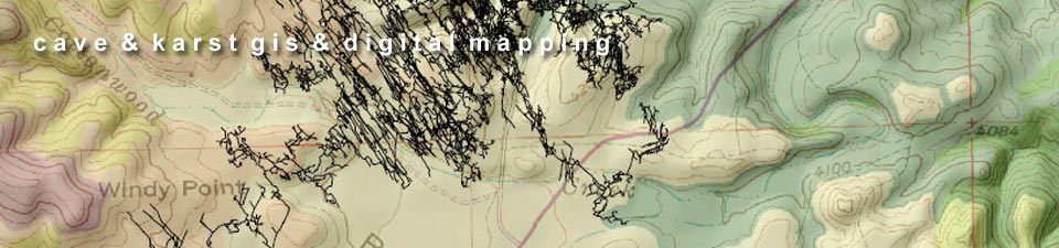
WIND CAVE & PARK GEOLOGY
This map was originally published in the Journal of Cave and Karst Studies Special GIS Issue and was created using ArcGIS Desktop (ArcView, 3D Analyst, and Spatial Analyst).
The cave survey data was exported using the same procedure as described for the map above. This map omits the DRG and generalized hillshade, but adds park geology showing the relationships of the surface outcrops of limestone and sandstone to the cave. The limestone and sandstone polygons were selected and extracted from the original park geology layer. The dashed line indicates the strike of the cave.
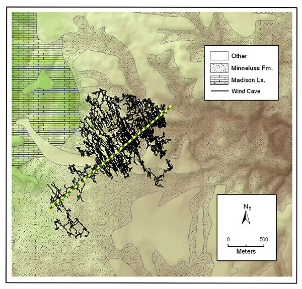
WIND CAVE NATIONAL PARK OVERVIEW
This map shows the location of the known surveyed extents (at the time of publication) of Wind Cave within the Wind Cave National Park boundary.
The boundary outline was provided by Wind Cave National Park. Elevation data was obtained from USGS DEMs, mosaiced, and clipped to the park boundary. Hillshades and other layers were derived from the DEM and manipulated/composited to produce the final basemap layer. Cave survey data was exported from Compass as described in the examples above, and drawn atop the basemap layers. Arrows showing primary geographic features, a north arrow, and scale were added to complete the map.
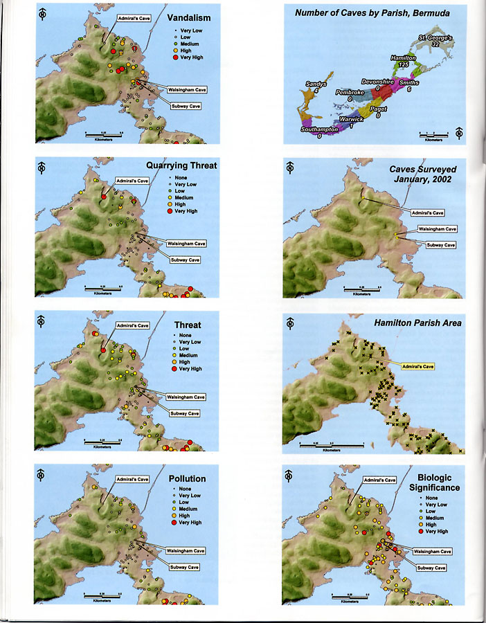
BERMUDA CAVES MAP SERIES
This map series was created for an article on Bermuda caves and the Bermuda Cave and Karst Information System (BeCKIS) project that appeared in the August, 2003, issue of the NSS News. Cave locations were added by importing lat/long coordinates from field data collected by Dr. Tom Iliffe. DEMs and parish boundaries were provided courtesy of the Bermuda Department of Planning.
Several derivative layers were created from the DEMs including hillshades and shaded elevation models. These were composited to produce the final basemap. Graduated size and color symbols were used to show the evaluated criteria (vandalism, threat, pollution, etc.) based on qualitative field observations.
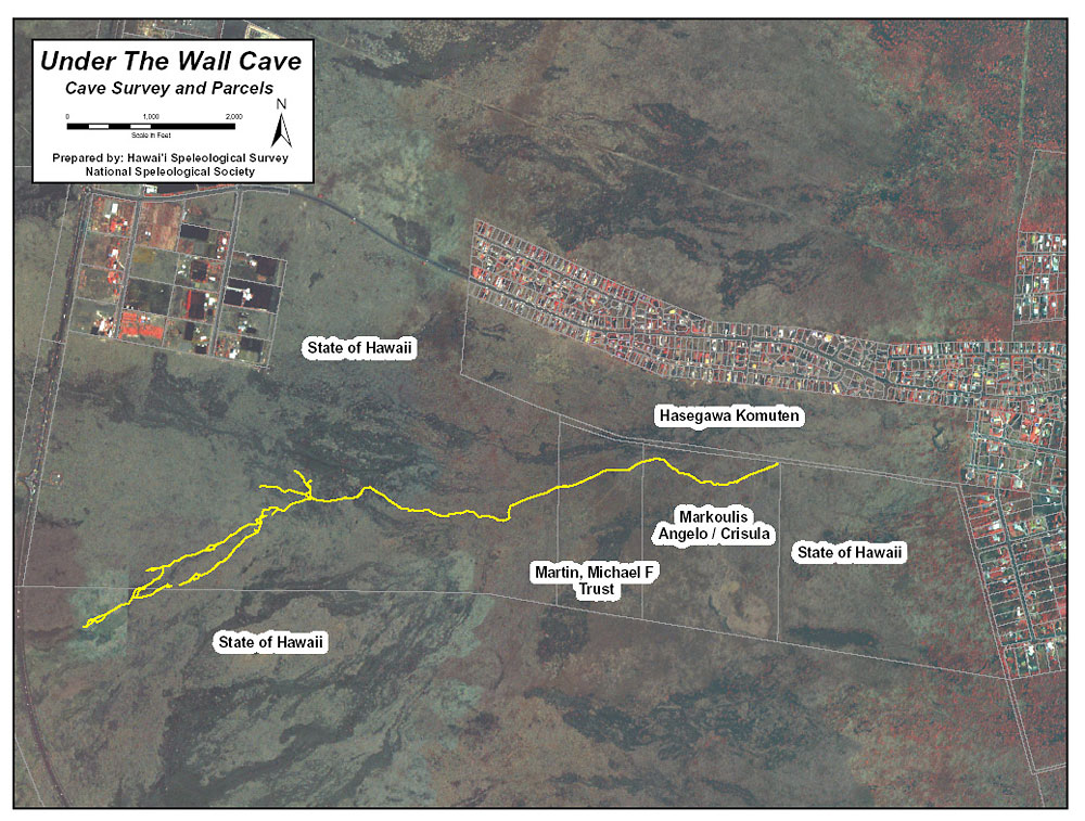
UNDER THE WALL CAVE
Under The Wall Cave is a lava tube located near a growing subdivision in Hawaii. The cave was surveyed by members of the Hawaii Speleological Survey. The cave survey data was exported from Compass as a shapefile, and georeferenced using tools in ArcGIS using GPS coordinates obtained at surface survey stations at the entrance puka and other pukas along the survey. Aerial imagery and parcel information (showing landowners under whose property the cave crosses) was obtained from the Hawaii State GIS clearinghouse. The map was used to show the development company where the cave is located so it could be preserved and protected.
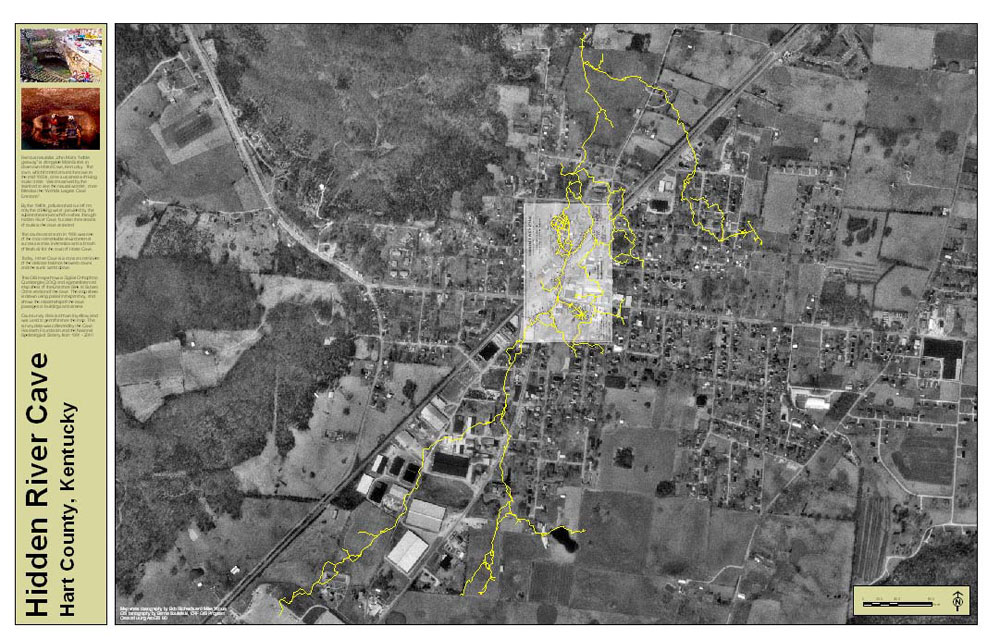
HIDDEN RIVER CAVE POSTER
This poster map shows the survey lineplot for Hidden River Cave overlain atop aerial imagery obtained from the USGS. One of the map sheets prepared for the Cave Research Foundation using Macromedia FreeHand (courtesy R. Richards) has been exported as a TIF file and has been georeferenced to the line plot to provide additional information about the extent of the cave in the downtown area. The layer containing the survey lines and stations was turned on prior to capturing the TIF image of the map sheet, making it very easy to identify and create links between the map and the survey stations and lines in the exported shapefiles.